Ben Singleton
Ben Singleton was the son of a convict and grew up in New South Wales. He worked as a miller on Wheeny Creek near Kurrajong. Ben was known as a good bushman and had already explored up the Macdonald River before the 1817 expedition with Parr.
Ben Singleton’s Investigations
 Ben Singletons Route
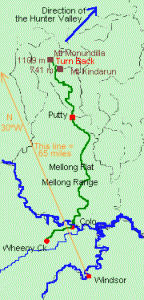
In April 1818, he set out with four men, including an Aboriginal guide, to find the route across the mountains to the Hunter River, following the same route he had travelled in 1817 with William Parr. On 27 April, they camped for the night at the Mellong Flats and on 28th they arrived at Putty at 12 o’clock.
From here he went out to the north-west, along the Mellong Range and, after struggling through very thick bush, reached a very high mountain. We do not know which one it was for certain, but it could have been Mt Kindarun which is 741 metres high (2430 ft). However, the highest peak is about 15 km to the northwest, Mt Monundilla reaching a height of 1109 metres (3640 ft). He could have had quite a good view from either of the peaks across to the Hunter Valley.
There he met some Aboriginal people who had never seen white men before. They told him that they would lead him to the Hunter River, the nearest good land. Singleton became afraid of the possible consequences of going with them and he turned for home instead, arriving on 14 May, saying that he thought he had travelled about 120 miles, north 30° west of Windsor. In those days, the only navigational tools most explorers used were a pocket compass for finding direction and a watch to estimate distances travelled, using approximate speed of walking and how long it had taken. This was clearly not a very accurate method and had to allow for delays caused by thick bush, difficult rock-climbs, water crossings or just bad weather. A quick mapping exercise will bring you to the realisation that his claim of travelling 120 miles out at a direction of N 30ºW from Windsor allowed for these issues, because travelling in a straight line he would have crossed the Wollemi Range and gone well out into the Western Plains, beyond Merriwa and almost out to Coolah. He clearly must have not only overestimated the distance he had travelled but been confused about the direction he had gone. He was actually still in the Wollemi Range, probably somewhere about where the map shows “Turn Back” amongst those high peaks.
Ben Singleton also claimed that he had made another journey late in 1819 and had come out on the Hunter River at Doyle’s Creek, later guiding John Howe there. This would have had to be the 1820 Expedition, because, John Howe’s journal clearly says that in 1819 his only guide was an Aboriginal man, Myles.

