Which Way North?

Imagine yourself arriving in Sydney back in the 1820s as a middle class free settler with capital to invest in farmland. Most of the good land around Sydney and out to the west has been taken up already and there is not much left around.
Up north, a penal settlement in Newcastle is moved to Port Macquarie and the area is no longer off-limits. Suddenly there is plenty of virgin land up for grabs. But how to get there? The only practicable way is by sea, fighting the southerly current under sail. Not appealing, if you have just spent six months being sea-sick on the way out from England.
Between Sydney and the Hunter River is a maze of fearsome sandstone mountains with deep gorges and razor-back ridges which suddenly end in towering bluffs. The area is criss-crossed with Aboriginal tracks but only the makers know where these go. Desperate settlers are swimming their stock over the Hawkesbury River and making their way along the rugged creeks, clearing the swampy flats and being washed away in the periodical floods. There is no proper road through. This is the story of the building of the Great North Road, supposedly the answer to the problem of access to the Hunter Valley.
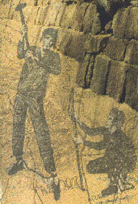
Using only hand tools and assisted by a few bullocks, toiling away in summer and winter with little protection from the elements and living on monotonous rations of meat, flour and corn meal food, several thousand convicts were employed to build the road over a period of nearly ten years. Their lives were hard but the road is a monument to their endurance and to the abilities which many showed in the work they did. This and other roads enabled the whole area between Sydney and Newcastle to be opened up. The young settlement of Sydney began to develop into the nation that is Australia today.
The story includes many elements of the history and geography related together and we hope to show what happened in the decisions and actions which led to the construction of the Great North Road, its use and its decline. Fortunately, some of the decline in its use protected it from final destruction and the subsequent decisions on preservation of the road have led to investigations which are fascinating in a wide variety of aspects.
The spread of the population to the north of Sydney and particularly to the district around the Hunter River produced the desire to have a good road communication system to the Hunter region. The use of sailing ships up the coast had been the only way and that was fraught with problems caused by weather conditions and the strong southerly flowing current. Wrecks were a common occurrence.
The Government and its officials could see the need for the road and had the vision of a road as good as any in England. A grand vision was born, urged on by Sir Thomas Mitchell, the Surveyor General. He was criticised roundly by many for his attempt at making this road a monument to his own glory. Background to the grand vision will develop as each section sets out to show.
The Route which the road should take had many alternatives. Various people had developed their own line for road communication. The factors which they advanced often had personal ulterior motives but some factor which could have been important appeared to be ignored such as the availability of grass, water and reasonable gradients in the road itself. The characters of people involved and the suggestions they put forward are explored wherever possible.
Finally we are confronted with the decline in maintenance of the road and the deviation from the Great North Road which was taken by those who saw the difficult sections of the road as unacceptable. It was the impact of the introduction of steamships, running between Sydney and Newcastle, that tolled the seeming death knell for this wonderful piece of road with its marvellous stonework, drains and road surface made to the then new technologies developed in England by Telford and Macadam.

