John Marquet Blaxland
 Blaxlands Route to Wollombi
John Blaxland was the nephew of the famous Gregory Blaxland who, in company with Lawson and Wentworth, found a way across the Blue Mountains in 1813. On January 4th, 1825, he wrote to the Surveyor General to say that he had found a way across the mountains to Wollombi. The Transcript reads as follows.
I have the honour to inform you of my having discovered a new and almost direct line of Road from Windsor to Wallis Plains, Hunters River, passing over the Two Branches of the Hawkesbury and through the Mountains, of which there is not more than Thirty-five miles, all easy of ascent. It is particularly well watered by perpetually flowing streamlets about five miles apart, and there is an abundance of grass, and through Wallumbi (Wollombi), a level and exceeding fine grazing country, from thence in almost a straight line to Wallis Plains over Verdant Hills and fertile vallies, all abundantly supplied with water. The distance as far as I can judge is not more than Ninety Miles, which will make a saving of upwards of forty miles. The Country through which I passed is superior in every respect for the making of a Road to that now used (the Bulga Road) and very considerably shorter.
The Blaxland route probably used a number of Aboriginal pathways, as it crosses many places where Aboriginal engravings can still be seen today. It crossed the Colo at Howe’s track, ran north-east along Wheelbarrow Ridge to the MacDonald River and then along a mountain ridge to Wollombi, through Blaxland’s own farm at Laguna. (This last section of his route is now known as the Boree Track and passes through Yengo National Park.
It is interesting to note here that Aboriginal pathways were found all over the country by early British travellers. The problem for the British explorers was to know where these pathways went. Some were connecting tracks from one area to another (useful for the newcomers), but others went to Aboriginal sacred or ceremonial places where they would not have been wanted and to which there was no need for them to go. As early as June 1789, Captain Phillip took a group to explore the northern side of the harbour, along the northern beaches as far as Pittwater. Captain Hunter, later to become Governor of New South Wales but at that time just an officer under Phillip, reported that they travelled north along the beaches but had to climb around the headlands between. He explained that they travelled these sections along “paths, which the natives, in travelling along the coast, had trod well down”. There were many such pathways through the bush and along the coast. The difficulty for the Surveyors was whether they went anywhere near to the places where they wanted to go. [Hunter, J.:Historical Journal of the Transactions at Port Jackson and Norfolk Island, 1793] Later, Alexander Harris, in his book Settlers and Convicts wrote, “I could not but wonder how the road we were now pursuing from Appin towards the coast had been discovered. I was not then aware that the aborigines are so well acquainted with the bush as to be able to point out the most practicable tracks in any direction.”
 Finches Line comparison
with Blaxlands Route
Returning to the Blaxland route to Wollombi, it became a popular track for droving animals, because it had feed and water. But the government did not choose it for the route of their Great North Road, favouring instead the Finch Line.
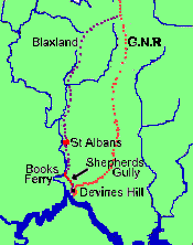
Soon after the Great North Road was built, a popular short-cut from Devine’s Hill down Shepherds Gully and along the MacDonald River joined Blaxland’s track, bypassing the most rugged sections of the Great North Road. In the map, the orange dots show that route of the Finch Line taken by the Great North Road. The purple dots show the route taken in the short-cut (red) from Devine’s Hill down Shepherds Gully to join the Blaxland route at about Books Ferry and thence on to St Albans and north.
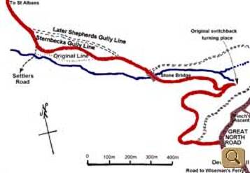
 Expanded map showing short cut route
This expanded version shows the short-cut (red) route in more detail (Courtesy A. Wickham 1997). The original route ran closer to the creek in one section. The road proceeded down Devine’s Hill with a switchback turning place in a constricted piece of the road. It went west across a stone bridge over Shepherds Gully Creek, along Sternbecks Gully line and on to St Albans, including Books Ferry. Some time later, a more direct Shepherds Gully Line was developed, cutting off some of the distance and bends in the Sternbecks Gully Line.

